Property Record
223 Whitley Rd, Bethlehem, GA 30620
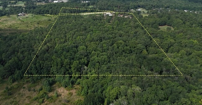

This Property Is For Sale
Property Detail
223 Whitley Rd
5-357-003
BETHELEHEM RT 1
Autorepair
GWINNETT
RA200
Georgia
A Areas with a 1% annual chance of flooding and a 26% chance of flooding over the life of a 30-year mortgage.
4
2025
43.60 AC
2025
Lawrenceville/Lilburn
180503
Atlanta
1,800 SF
Atlanta-Sandy Springs-Roswell, GA
NEARBY LISTINGS FOR SALE OR LEASE
DEMOGRAPHICS near 223 Whitley Rd
1 mile
3 mile
5 mile
2025 Total Population
834
19,242
62,825
2030 Population
870
20,938
68,738
Pop Growth 2025-2030
+ 4.32%
+ 8.81%
+ 9.41%
Average Age
40
36
37
2025 Total Households
266
6,040
19,607
HH Growth 2025-2030
+ 4.51%
+ 9.07%
+ 9.70%
Median Household Inc
$88,414
$91,991
$92,404
Avg Household Size
3.10
3.20
3.20
2025 Avg HH Vehicles
3.00
2.00
2.00
Median Home Value
$443,662
$383,739
$371,782
Median Year Built
2001
2005
2003
Nearby Places
Map Layers
Map Styles
 Street
 Aerial
Transit
 Traffic
 Biking
Places
Listings with unknown addresses are not visible on the map
- Restaurants
- Banks
- Shops
- Fitness
- Groceries
Nearby Properties
Address
Land Use
TOTAL SIZE
Lot Size
Zoning
Address
Land Use
TOTAL SIZE
Lot Size
Zoning
637.87 AC
RA200
Address
Land Use
TOTAL SIZE
Lot Size
Zoning
10,128 SF
28.19 AC
R-3
Address
Land Use
TOTAL SIZE
Lot Size
Zoning
103.23 AC
R100MOD
Address
Land Use
TOTAL SIZE
Lot Size
Zoning
420,876 SF
26.84 AC
M-2
Address
Land Use
TOTAL SIZE
Lot Size
Zoning
164,877 SF
34.89 AC
C1
Address
Land Use
TOTAL SIZE
Lot Size
Zoning
120,000 SF
142.73 AC
AG
Address
Land Use
TOTAL SIZE
Lot Size
Zoning
305,327 SF
22.05 AC
M-2
Address
Land Use
TOTAL SIZE
Lot Size
Zoning
301,200 SF
39.18 AC
M-2
Address
Land Use
TOTAL SIZE
Lot Size
Zoning
47,141 SF
8.29 AC
AG
Address
Land Use
TOTAL SIZE
Lot Size
Zoning
231,285 SF
34.50 AC
M-2
Address
Land Use
TOTAL SIZE
Lot Size
Zoning
167,580 SF
21.82 AC
M-2
Address
Land Use
TOTAL SIZE
Lot Size
Zoning
183,060 SF
17.90 AC
M-2
Address
Land Use
TOTAL SIZE
Lot Size
Zoning
89,520 SF
13.99 AC
M-2
Address
Land Use
TOTAL SIZE
Lot Size
Zoning
23,546 SF
24.55 AC
RA200
Address
Land Use
TOTAL SIZE
Lot Size
Zoning
64,800 SF
47.27 AC
M-1
Address
Land Use
TOTAL SIZE
Lot Size
Zoning
20,660 SF
10.94 AC
RA200
Address
Land Use
TOTAL SIZE
Lot Size
Zoning
38,550 SF
3.04 AC
C-2
Address
Land Use
TOTAL SIZE
Lot Size
Zoning
15,808 SF
16.43 AC
RA200
Address
Land Use
TOTAL SIZE
Lot Size
Zoning
16,384 SF
5.10 AC
RA200
Address
Land Use
TOTAL SIZE
Lot Size
Zoning
212.21 AC
RA200
Address
Land Use
TOTAL SIZE
Lot Size
Zoning
153 AC
R100
Address
Land Use
TOTAL SIZE
Lot Size
Zoning
151.81 AC
Address
Land Use
TOTAL SIZE
Lot Size
Zoning
1,036 SF
120.72 AC
C1
Address
Land Use
TOTAL SIZE
Lot Size
Zoning
107.74 AC
RA200
Address
Land Use
TOTAL SIZE
Lot Size
Zoning
117.24 AC
RA200
Address
Land Use
TOTAL SIZE
Lot Size
Zoning
105.46 AC
Address
Land Use
TOTAL SIZE
Lot Size
Zoning
166.81 AC
RA200
Address
Land Use
TOTAL SIZE
Lot Size
Zoning
95.60 AC
RA200
Address
Land Use
TOTAL SIZE
Lot Size
Zoning
5,198 SF
8 AC
RA200
Address
Land Use
TOTAL SIZE
Lot Size
Zoning
49,527 SF
19.22 AC
M-2
The World's #1 Commercial Real Estate Marketplace
Connect with us
© 2026 CoStar Group
The information above has been obtained from sources believed reliable. While we do not doubt its accuracy we have not verified it and make no guarantee, warranty or representation about it. It is your responsibility to independently confirm its accuracy and completeness. Any projections, opinions, assumptions, or estimates used are for example only and do not represent the current or future performance of the property. The value of this transaction to you depends on tax and other factors which should be evaluated by your tax, financial, and legal advisors. You and your advisors should conduct a careful, independent investigation of the property to determine to your satisfaction the suitability of the property for your needs.